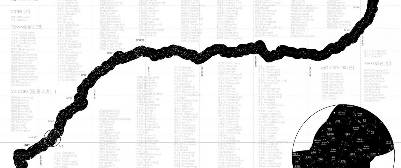
533 Places: Tracing the Forgotten Places in the Demilitarized Zone (DMZ)
This preliminary map sheds light on the forgotten 533 places within the Korean Demilitarized Zone (DMZ). The DMZ is a 250-km long and 4-km wide buffer zone that has been bisecting the Korean peninsula since the end of the Korean War in 1953. The names of the 533 places include 466 villages, 20 townships, 13 mountains, 12 rivers, and two cities marked within the boundaries of the Demilitarized Zone in the original 1953 Armistice Agreement map, a piece of document intended for the “the peaceful settlement of the Korean question” of all military forces involved at the time. No one would have imagined that the DMZ would still exist in 2022, some 69 years later.
Under the Armistice Agreement, “no person, military or civilian” is allowed to enter or cross the DMZ unless authorized. Since the official signing of the Agreement, the inhabitants of these 533 villages were forced to leave their homes and abandon their hometowns to go to either North or South Korea. These places within the DMZ have since been inaccessible, uninhabited, and mostly forgotten for the last 69 years. One of the main aims of this map is to better understand the impacts of political borders on human settlements, especially when access to a place is severely restricted for an extended period. Further, it attempts to highlight the history of the under-documented villages within the DMZ in contrast to the better-studied new strategic post-Korean War re-settlements near the border regions such as the Unification Villages, Tongilchon on the South Korean side.
The 533 names shown on this map were extracted, traced, categorized, and listed from the 1:50,000 scaled Armistice Agreement map. These forgotten names and places show how abstract lines on a map could extensively impact people’s daily lives in zones of conflict. They also illustrate how arbitrarily drawn-up lines, i.e. territorial borders, have been inscribed into people’s daily lives that cause long-term human suffering. In addition, the North Korean government has demarcated a “Special Military Region” drawn up to 50-km away from the DMZ, which has further prevented civilian access to the border regions. The South Korean side of border is equally highly restricted through the additional “Civilian Control Area” buffer zone that range between 15-20-km away from the Military Demarcation Line (MDL). These lines and zones exacerbate the historical amnesia as silent markers of separation.
Villages Chunggang-ni, Hongwon-ni, Unjong-ni listed on this map are some of the few 533 forgotten places extracted from the Armistice Map. These villages were populated before the Korean War. They were prosperous places close to Cheorwon, one of the largest transportation hubs on the Kyoungwon Main Line railway network and one of the top rice-producing regions. Nevertheless, it is challenging to find in-depth historical information on these places and what happened to their residents after the Korean War due to long-term neglect and indifference towards these places.
This one-of-a-kind preliminary map of the forgotten 533 places acknowledges the history of the DMZ, emphasizing what existed and who lived there before the Armistice Agreement, eliciting emotions and memories of homes and homelands. This map challenges the dominant representations of the DMZ as a tabula rasa; instead, the mapping raises several questions: Who were the individuals that used to live in these places? How many were there? How and when did they leave? Where did they go? Are those who have lost their homes and hometowns still alive? Has the DMZ been taken over by flora and fauna over the years? How has nature transformed these places? What happens when the DMZ becomes accessible again? And when that happens, who would be entitled to claim ownership of what remains within the DMZ?
Follow this link and watch the animated map of the DMZ: “A Construct the Koreas (Never) Made Together: Deconstructing the DMZ for the Imaginary-2019”
Dongsei Kim, Assistant Professor, New York Institute of Technology
@dongseikim
Add new comment